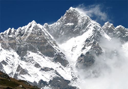
Mahalangur Himal, Koshi Province
Lhotse
also लहोत्से · Lho Tse
8,516 m27,940 ft27.962°N 86.933°E
At a glance
- Elevation
- 8,516 m · 27,940 ft[1]
- Prominence
- 610 m[1]
- Range
- Mahalangur Himal[1]
- Region
- Solukhumbu District, Koshi Province[2]
- Coordinates
- 27.9617° N, 86.9333° E[1]
- First ascent
- 18 May 1956, Ernst Reiss & Fritz Luchsinger[2]
Elevation is height above sea level; prominence is how far it rises above the lowest col connecting it to higher ground.
The mountain's story
Lhotse, Tibetan for 'South Peak', is the fourth-highest mountain on Earth at 8,516 metres, on the border between Tibet and Nepal's Khumbu region. With Everest to the north and Nuptse to the west, it forms the apex of the great horseshoe-shaped arc of the Everest massif.[2]
Because the South Col connecting it to Everest is so high, Lhotse is the least prominent of the eight-thousanders, despite the enormous relief of its South Face. Its Western Face is part of the standard routes on both peaks. Ernst Reiss and Fritz Luchsinger of a Swiss expedition made the first ascent of the main summit on 18 May 1956.[2]
Little things worth knowing
- 1
Four summits
The main ridge carries Lhotse Main (8,516 m), Lhotse Middle (8,414 m), Lhotse Shar (8,383 m) and Lhotse Central II (8,372 m).[2]
- 2
Last unclimbed
Lhotse Middle long stood as the highest unclimbed named point on Earth, until a Russian team reached it on 23 May 2001.[2]
- 3
Shared route
Climbers bound for Everest and Lhotse both climb the Lhotse Face above the Western Cwm.[2]
Where it lives
Summit coordinates from Wikidata; hollow dots are viewpoints from which this peak is documented as visible.
Look closer
Culture & meaning
- Names and documented meaning
The name means 'South Peak' in Tibetan, reflecting its relationship to Everest.[2]
If you want to visit
Places from which Lhotse is documented as visible:
Permits, fees and access rules change. Check current requirements with the Nepal Tourism Board before you travel. We don't list routes or logistics we can't keep current.
Sources & further reading
5 sources
- [1]Wikidata item Q168702, Wikidata, retrieved 2026-10-23 · accessed 2026-10-23
- [2]Lhotse, Wikipedia · accessed 2026-10-23
- [3]Dhulikhel, Wikipedia · accessed 2026-10-23
- [4]Kala Patthar, Wikipedia · accessed 2026-10-23
- [5]Gokyo Ri, Wikipedia · accessed 2026-10-23
Structured values (elevation, coordinates, prominence) come from Wikidata, which aggregates survey sources. Wikipedia articles are used as secondary references; we prefer primary survey and expedition records as we add them. Last verified 2026-10-23.